


وصف لـ Satfinder (Dish Pointer): Quick Dish Align!
- 2 modes: GPS-OFF (take advantage of satellite maps to off-site express check intended location for possible satellite signal blocks before you actually setup the dish) and GPS-ON (aligning the dish);
- 2 types of target: Satellite (choose a certain satellite from a list) and Direction (set specific direction, which is good for aligning point-to-point wireless communication antennas);
- 4 map types;
- Easy to use search by either a satellite's own name or satellite provider's name;
- Access to a public transponder list;
- Magnetic azimuth display for hard-core compass fans!)
- Our love and care!☺We support you and answer all your questions, just send us feedback by pressing “Contact developer” button in the menu or send e-mail at artemkaxboy@gmail.com;
- Last but not least: we don’t run super-annoying huge ads in your face - good for nervous system and usability, friends!
to express check any point on planet Earth for satellite signal blocks:
1) Turn off GPS in the menu;
2) Choose a satellite or set direction;
3) Find intended location of dish setup and fix it with a long tap → Direction indicator and alignment parameters will show up, now you can have a look at the map and decide if that location is adequate or it's better to find another one.
Now you are ready for the main part, let’s roll!
(easy, really):
1. Make sure that the internet and GPS are enabled on your phone; bear in mind that for best accuracy you should be outdoor, or at least come close to a window;
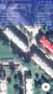
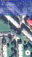
2. In the menu go to «Target» and choose a satellite/set direction → You will see your location and direction indicator on the map, and your coordinates, GPS status along with alignment parameters in the info panel at the top of your display;
3. Wait for max accuracy of GPS (it may take some time to determine your location). Accuracy depends on surroundings, good range is <5m/15ft;
4. Bring your phone to the dish as close as possible, no matter above or under it (you can stand right under the dish if it's fixed on a wall, just don’t step away);
5. Look at the map, if direction indicator runs across a landmark that is easy to spot from the dish location (a house, a lake, a big tree etc.) you can point the dish at the landmark, set elevation according to its value in the info panel and then proceed to fine-tuning the dish using a satellite receiver settings.
6. Fix the dish location with a long tap on the display or select the respective option in the menu → Coordinates will be saved and direction indicator will now be coming from the fixed location, not your actual one;
7. Following the direction indicator step about 100-300m (300-1000 ft) away from the dish, the farther you move away the better → You will see the azimuth for aligning your dish (“ Azimuth”) and azimuth calculated for your current location (“Current Azimut”), make sure the two values match as closely as possible;
8. At the point of closest azimuth match, place a landmark. For instance, it can be a stick/twig forced in the ground or a chair if you bring it, or even a person who is willing to stay still for a while;
9. Go back to your satellite dish, point it at the new landmark and set elevation;
10. Proceed to fine-tuning the dish using satellite receiver settings.
There now, your satellite dish is well aligned! Directv, dish network, all sorts of dish tv and internet are there - enjoy! 😁
Satfinder (Dish Pointer): Quick Dish Align! - إصدار 4.8.2
(17-12-2023)

Satfinder (Dish Pointer): Quick Dish Align! - معلومات APK
نُسخة APK: 4.8.2الحزمة: com.artemkaxboy.android.sputnikتطبيقات من الفئة نفسها
قد يعجبك أيضًا...


